Geolocate

Pleven topographic map

Click on the map to display elevation.

About this map

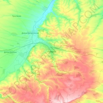
Name: Pleven topographic map, elevation, terrain.

Location: Pleven, 5805, Bulgaria (43.24902 24.45801 43.56902 24.77801)

Average elevation: 190 m

Minimum elevation: 32 m

Maximum elevation: 415 m

Other topographic maps

Click on a map to view its topography, its elevation and its terrain.

Nikopol

Bulgaria > Pleven

Average elevation: 95 m

Tatari

Bulgaria > Pleven

Average elevation: 74 m

Nikopol

Bulgaria > Pleven

Average elevation: 95 m

Gear up for your next adventure:

🛶Waterproof Dry Bags - Keep electronics and clothes dry during river crossings
🥾Waterproof Hiking Boots - Boots keeping your feet dry in wet conditions
🥤Collapsible Travel Cup - Saves space and weight in your mess kit
🎒Hiking Daypack - Lightweight and durable backpacks for day trips and excursions
🚲Heavy Duty Bike Lock - Secure your bike at the trailhead or during stops

As an Amazon Associate, this site earns from qualifying purchases at no extra cost to you.