Geolocate

Piacenza topographic map

Click on the map to display elevation.

About this map
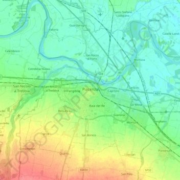
Name: Piacenza topographic map, elevation, terrain.

Location: Piacenza, Emilia-Romagna, Italy (44.99238 9.60056 45.11323 9.82523)

Average elevation: 60 m

Minimum elevation: 40 m

Maximum elevation: 106 m

Other topographic maps

Click on a map to view its topography, its elevation and its terrain.

Casella

Italy > Emilia-Romagna > Piacenza > Bettola

Average elevation: 786 m

Pianazze

Italy > Emilia-Romagna > Piacenza > Vernasca

Average elevation: 347 m

Ramara

Italy > Emilia-Romagna > Piacenza > Cadeo

Average elevation: 57 m

Fiorano

Italy > Emilia-Romagna > Piacenza > Travo

Average elevation: 284 m

Dadomo

Italy > Emilia-Romagna > Piacenza > Vernasca

Average elevation: 690 m

Crocinito

Italy > Emilia-Romagna > Piacenza

Average elevation: 565 m

Bogli

Italy > Emilia-Romagna > Piacenza > Ottone

Average elevation: 1,188 m

Misano

Italy > Emilia-Romagna > Piacenza > Agazzano

Average elevation: 240 m

Sariano

Italy > Emilia-Romagna > Piacenza > Gropparello

Average elevation: 266 m

Capannette di Pej

Italy > Emilia-Romagna > Piacenza > Zerba

Average elevation: 1,312 m

Gear up for your next adventure:

📷Outdoor Action Camera - Capture high-elevation views and rugged adventures
👖Convertible Hiking Pants - Zip-off legs to adapt to changing weather conditions
🥾Mountain Trail Shoes - High-traction shoes for mountain trails
🧼Biodegradable Camp Soap - Environmentally friendly cleaning for gear and body
🧢Hiking Hat - Sun-protective and breathable hats for long treks

As an Amazon Associate, this site earns from qualifying purchases at no extra cost to you.