Geolocate

Melnik topographic map

Click on the map to display elevation.

About this map

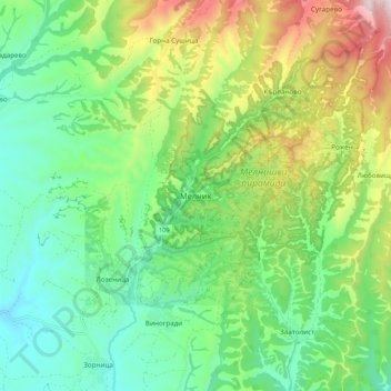
Name: Melnik topographic map, elevation, terrain.

Location: Melnik, Sandanski, Blagoevgrad, 2820, Bulgaria (41.48294 23.35325 41.56294 23.43325)

Average elevation: 450 m

Minimum elevation: 184 m

Maximum elevation: 1,001 m

Other topographic maps

Click on a map to view its topography, its elevation and its terrain.

Рупите

Bulgaria > Blagoevgrad

Average elevation: 117 m

Тевно езеро

Bulgaria > Blagoevgrad

Average elevation: 2,429 m

Frog lake

Bulgaria > Blagoevgrad

Average elevation: 2,410 m

Gear up for your next adventure:

🥾Trail Running Shoes - Lightweight and durable shoes for trail running
🧥Softshell Hiking Jacket - The perfect balance of wind protection and breathability
🔭Outdoor Binoculars - Lightweight binoculars for birdwatching and hiking
🧴Insect Repellent - Protect yourself from bugs during outdoor adventures
Family Camping Tent - Spacious tent suitable for family camping trips

As an Amazon Associate, this site earns from qualifying purchases at no extra cost to you.