
Make a donation
Gear up for your next adventure:
As an Amazon Associate, this site earns from qualifying purchases at no extra cost to you.
Warwick Township topographic map
Click on the map to display elevation.
Make a donation
Gear up for your next adventure:
As an Amazon Associate, this site earns from qualifying purchases at no extra cost to you.
About this map
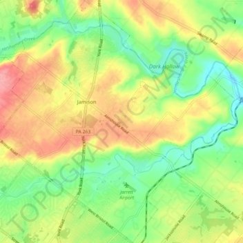
Name: Warwick Township topographic map, elevation, terrain.
Average elevation: 80 m
Minimum elevation: 38 m
Maximum elevation: 129 m
Make a donation
Gear up for your next adventure:
As an Amazon Associate, this site earns from qualifying purchases at no extra cost to you.
Other topographic maps
Click on a map to view its topography, its elevation and its terrain.
Tyler State Park
United States > Pennsylvania > Bucks County > Northampton Township
Average elevation: 67 m
Pipersville
United States > Pennsylvania > Bucks County > Bedminster Township
Average elevation: 125 m
Langhorne Gardens
United States > Pennsylvania > Bucks County > Middletown Township
Average elevation: 45 m
Make a donation
Gear up for your next adventure:
As an Amazon Associate, this site earns from qualifying purchases at no extra cost to you.
Croydon Heights
United States > Pennsylvania > Bucks County > Bristol Township > Croydon
Average elevation: 10 m
Make a donation
Gear up for your next adventure:
As an Amazon Associate, this site earns from qualifying purchases at no extra cost to you.
Kintnersville
United States > Pennsylvania > Bucks County > Nockamixon Township
Average elevation: 113 m
Make a donation
Gear up for your next adventure:
As an Amazon Associate, this site earns from qualifying purchases at no extra cost to you.
Newtown Athletic Club
United States > Pennsylvania > Bucks County > Newtown Township
Average elevation: 49 m
Blue Ridge
United States > Pennsylvania > Bucks County > Bristol Township > Levittown
Average elevation: 16 m
Falls Township Community Park
United States > Pennsylvania > Bucks County > Falls Township > Wheat Sheaf
Average elevation: 9 m
Make a donation
Gear up for your next adventure:
As an Amazon Associate, this site earns from qualifying purchases at no extra cost to you.
Plumsteadville
United States > Pennsylvania > Bucks County > Plumstead Township
Average elevation: 160 m
Taylorsville
United States > Pennsylvania > Bucks County > Upper Makefield Township > Washington Crossing
Average elevation: 37 m
Springtown
United States > Pennsylvania > Bucks County > Springfield Township
Average elevation: 163 m
Make a donation
Gear up for your next adventure:
As an Amazon Associate, this site earns from qualifying purchases at no extra cost to you.
Blue Ridge
United States > Pennsylvania > Bucks County > Bristol Township > Levittown
Average elevation: 16 m
Wrightstown
United States > Pennsylvania > Bucks County > Wrightstown Township
Average elevation: 85 m
Make a donation
Gear up for your next adventure:
As an Amazon Associate, this site earns from qualifying purchases at no extra cost to you.
Mechanicsville
United States > Pennsylvania > Bucks County > Buckingham Township
Average elevation: 117 m
Southampton
United States > Pennsylvania > Bucks County > Upper Southampton Township
Average elevation: 75 m
Southampton
United States > Pennsylvania > Bucks County > Upper Southampton Township
Average elevation: 75 m
Make a donation
Gear up for your next adventure:
As an Amazon Associate, this site earns from qualifying purchases at no extra cost to you.
Landisville
United States > Pennsylvania > Bucks County > Buckingham Township
Average elevation: 121 m
Make a donation
Gear up for your next adventure:
As an Amazon Associate, this site earns from qualifying purchases at no extra cost to you.
Make a donation
Gear up for your next adventure:
As an Amazon Associate, this site earns from qualifying purchases at no extra cost to you.
Blooming Glen
United States > Pennsylvania > Bucks County > Hilltown Township
Average elevation: 131 m
Eddington Gardens
United States > Pennsylvania > Bucks County > Bensalem Township > Eddington Gardens
Average elevation: 29 m
Croydon
United States > Pennsylvania > Bucks County > Bristol Township > Croydon
Average elevation: 8 m
Make a donation
Gear up for your next adventure:
As an Amazon Associate, this site earns from qualifying purchases at no extra cost to you.
Red Cedar Hill
United States > Pennsylvania > Bucks County > Bristol Township > Levittown > Red Cedar Hill
Average elevation: 21 m
Kintnersville
United States > Pennsylvania > Bucks County > Nockamixon Township
Average elevation: 113 m
Bridge Point
United States > Pennsylvania > Bucks County > Doylestown Township
Average elevation: 82 m
Make a donation
Gear up for your next adventure:
As an Amazon Associate, this site earns from qualifying purchases at no extra cost to you.