
Blue Ridge topographic map
Click on the map to display elevation.
About this map
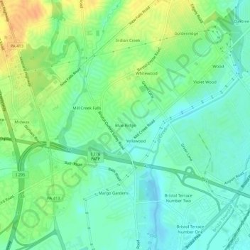
Name: Blue Ridge topographic map, elevation, terrain.
Average elevation: 16 m
Minimum elevation: 3 m
Maximum elevation: 37 m
Other topographic maps
Click on a map to view its topography, its elevation and its terrain.
Levittown
United States > Pennsylvania > Bucks County > Bristol Township > Levittown
Average elevation: 18 m
Levittown
United States > Pennsylvania > Bucks County > Bristol Township > Levittown
Average elevation: 18 m
Levittown
United States > Pennsylvania > Bucks County > Bristol Township > Levittown
Average elevation: 18 m
Levittown
United States > Pennsylvania > Bucks County > Bristol Township > Levittown
Average elevation: 18 m