Geolocate

Pollença topographic map

Click on the map to display elevation.

About this map

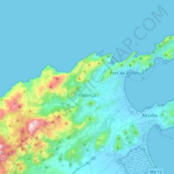
Name: Pollença topographic map, elevation, terrain.

Location: Pollença, Serra de Tramuntana, Balearic Islands, Spain (39.81663 2.92104 39.96251 3.21446)

Average elevation: 115 m

Minimum elevation: -4 m

Maximum elevation: 1,093 m

Other topographic maps

Click on a map to view its topography, its elevation and its terrain.

Gear up for your next adventure:

🎒Fully Waterproof Backpack - Total protection for photography gear and electronics
🧥Packable Rain Jacket - Breathable waterproof layer for unpredictable weather
🔦UV Flashlight - Detect minerals or specific insects in the dark
💧Collapsible Water Bottle - Space-saving water bottle for outdoor activities
Lightweight Camping Tent - Portable shelter optimized for Canadian backcountry camping

As an Amazon Associate, this site earns from qualifying purchases at no extra cost to you.