Geolocate

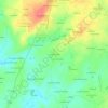
53470 topographic map

Click on the map to display elevation.

About this map

Name: 53470 topographic map, elevation, terrain.

Location: 53470, Martigné-sur-Mayenne, Mayenne, Pays de la Loire, France métropolitaine, France (48.13409 -0.73249 48.25778 -0.57190)

Average elevation: 120 m

Minimum elevation: 64 m

Maximum elevation: 166 m

Other topographic maps

Click on a map to view its topography, its elevation and its terrain.
Gear up for your next adventure:

🧼Biodegradable Camp Soap - Environmentally friendly cleaning for gear and body
🧥Waterproof Hiking Jacket - Protect yourself from rain and wind while hiking
🧥Waterproof Jacket - Lightweight rain jackets for hiking and outdoor activities
🥾Hiking Shoes - Durable and comfortable shoes for trail hiking
🚲MTB Frame Bag - Carry tools and maps directly on your bicycle frame

As an Amazon Associate, this site earns from qualifying purchases at no extra cost to you.