Geolocate

Madison topographic map

Click on the map to display elevation.

About this map
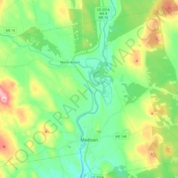
Name: Madison topographic map, elevation, terrain.

Location: Madison, Somerset County, Maine, 04950, United States (44.76918 -69.89192 44.90107 -69.71901)

Average elevation: 124 m

Minimum elevation: 48 m

Maximum elevation: 292 m

Other topographic maps

Click on a map to view its topography, its elevation and its terrain.
Pratt Hill

United States > Maine > Somerset County > Skowhegan

Average elevation: 113 m

Bigelow Hill

United States > Maine > Somerset County > Skowhegan

Average elevation: 158 m

Mackamp

United States > Maine > Somerset County

Average elevation: 395 m

Gray Island

United States > Maine > Somerset County > Solon

Average elevation: 105 m

Norris Brook

United States > Maine > Somerset County

Average elevation: 420 m

Gear up for your next adventure:

🛶Waterproof Dry Bags - Keep electronics and clothes dry during river crossings
🧥Waterproof Jacket - Lightweight rain jackets for hiking and outdoor activities
🧴First Aid Kit - Essential first aid supplies for outdoor emergencies
👟Leg Gaiters - Keep debris, mud, and snow out of your boots
🕶️Polarized Sunglasses - Reduces glare from snow and water at high elevations

As an Amazon Associate, this site earns from qualifying purchases at no extra cost to you.