Geolocate

Black Cat Ridge topographic map

Click on the map to display elevation.

About this map
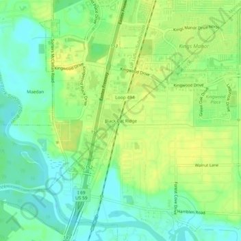
Name: Black Cat Ridge topographic map, elevation, terrain.

Location: Black Cat Ridge, Houston, Harris County, Texas, 77339, United States (30.02362 -95.26957 30.06362 -95.22957)

Average elevation: 24 m

Minimum elevation: 13 m

Maximum elevation: 33 m

Other topographic maps

Click on a map to view its topography, its elevation and its terrain.
Yellowstone Park

United States > Texas > Harris County > Houston

Average elevation: 15 m

Fosters Mill

United States > Texas > Harris County > Houston

Average elevation: 21 m

Mandell Park

United States > Texas > Harris County > Houston

Average elevation: 18 m

Brady Island

United States > Texas > Harris County > Houston

Average elevation: 9 m

Discovery Green

United States > Texas > Harris County > Houston

Average elevation: 16 m

Cypress Creek

United States > Texas > Harris County > Houston

Average elevation: 35 m

Memorial Park

United States > Texas > Harris County > Houston

Average elevation: 21 m

Tuffly Park

United States > Texas > Harris County > Houston

Average elevation: 16 m

Gear up for your next adventure:

🔦LED Headtorch - Bright and durable light for night activities
🎒Hiking Backpack - Lightweight and ergonomic backpacks for day hikes or multi-day treks
🧥Softshell Hiking Jacket - The perfect balance of wind protection and breathability
🛌Down Sleeping Bag - Superior warmth-to-weight ratio for cold nights
⛺Camping Essentials - All-in-one gear for a comfortable camping trip

As an Amazon Associate, this site earns from qualifying purchases at no extra cost to you.