Geolocate
👉 Easily get elevation data in JSON, GeoTIFF and KML formats using Elevation API
Thank you for supporting this site ❤️
Make a donation

Taysan topographic map

Click on the map to display elevation.

About this map

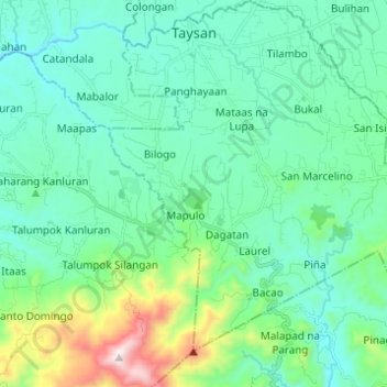
Name: Taysan topographic map, elevation, terrain.

Location: Taysan, Batangas, Calabarzon, 4228, Philippines (13.68836 121.16136 13.80750 121.27176)

Average elevation: 203 m

Minimum elevation: 22 m

Maximum elevation: 946 m

Other topographic maps

Click on a map to view its topography, its elevation and its terrain.

Poblacion

Philippines > Batangas > Taal

Average elevation: 26 m

Talisay

Philippines > Batangas > Lipa

Average elevation: 363 m

Fabrica

Philippines > Batangas > Lobo

Average elevation: 20 m

Balitoc

Philippines > Batangas > Calatagan

Average elevation: 13 m

Palsara

Philippines > Batangas > Balete

Average elevation: 58 m

Malaking Pulo

Philippines > Batangas > Tanauan

Average elevation: 178 m

Calle

Philippines > Batangas > Tanauan

Average elevation: 150 m

Talahib Pandayan

Philippines > Batangas > Batangas City

Average elevation: 60 m

San Pedro II

Philippines > Batangas > Malvar

Average elevation: 174 m

Dayap

Philippines > Batangas > Nasugbu

Average elevation: 43 m

Gear up for your next adventure:

🩹Compact First Aid Kit - Pre-packed essentials for common trail injuries
🧥Thermal Fleece Jacket - Versatile insulation for changing mountain temperatures
🛏️Sleeping Bag - Warm and compact sleeping bags for outdoor camping
Camping Groundsheet - Protect your tent from moisture and dirt
Camping Coffee Maker - Brew fresh coffee anywhere on the topographic map

As an Amazon Associate, this site earns from qualifying purchases at no extra cost to you.