Geolocate

Palsara topographic map

Click on the map to display elevation.

About this map

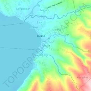
Name: Palsara topographic map, elevation, terrain.

Location: Palsara, Balete, Batangas, Calabarzon, 4219, Philippines (13.99304 121.07739 14.03304 121.11739)

Average elevation: 58 m

Minimum elevation: -2 m

Maximum elevation: 239 m

Gear up for your next adventure:

💡Compact LED Flashlight - Powerful and portable flashlight for outdoor use
🚑Survival Whistle - Signal for help across long distances in mountains
🪜Heavy Duty Carabiners - Multi-use clips for securing gear to your backpack
🏃Hydration Running Vest - Carry water and maps close to your body for speed
💧Hydration Pack - Hands-free hydration system for long hikes

As an Amazon Associate, this site earns from qualifying purchases at no extra cost to you.