
Mount Baldy topographic map
Click on the map to display elevation.
About this map
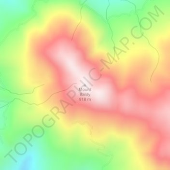
Name: Mount Baldy topographic map, elevation, terrain.
Location: Mount Baldy, Humboldt County, California, United States (40.38176 -123.87120 40.38186 -123.87110)
Average elevation: 613 m
Minimum elevation: 269 m
Maximum elevation: 897 m
Other topographic maps
Click on a map to view its topography, its elevation and its terrain.
Trinidad
United States > California > Humboldt County
Trinidad (Spanish for "Trinity"; Yurok: Chuerey) is a seaside city in Humboldt County, located on the Pacific Ocean 8 miles (13 km) north of the Arcata-Eureka Airport and 15 miles (24 km) north of the college town of Arcata. Trinidad is noted for its coastline, with ten public beaches and offshore rocks, part…
Average elevation: 38 m