
Trinidad topographic map
Click on the map to display elevation.
Trinidad
Trinidad (Spanish for "Trinity"; Yurok: Chuerey) is a seaside city in Humboldt County, located on the Pacific Ocean 8 miles (13 km) north of the Arcata-Eureka Airport and 15 miles (24 km) north of the college town of Arcata. Trinidad is noted for its coastline, with ten public beaches and offshore rocks, part of the California Coastal National Monument, of which Trinidad is a "Gateway City." Fishing operations related to Trinidad Harbor are vital to both local tourism and commercial fishing interests in the region. Situated at an elevation of 174 feet (53 m) above its own North Coast harbor, Trinidad is one of California's smallest incorporated cities by population, with 367 residents in 2010, up from 311 residents in 2000.
About this map
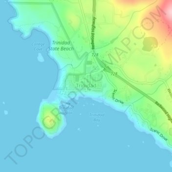
Name: Trinidad topographic map, elevation, terrain.
Location: Trinidad, Humboldt County, California, United States (41.05094 -124.15349 41.06736 -124.13300)
Average elevation: 38 m
Minimum elevation: -2 m
Maximum elevation: 191 m
Other topographic maps
Click on a map to view its topography, its elevation and its terrain.
Eureka
United States > California > Humboldt County > Eureka
The city marina is on one of three islands at a narrow point on the 13-mile-long (21 km) bay and increases in elevation slightly as it spreads north, south, and especially to the east. The city gently encroaches at least two miles (3.2 km) eastward into primarily Redwood and Douglas-fir second growth forests.…
Average elevation: 100 m