Geolocate

Fortuna topographic map

Click on the map to display elevation.

About this map

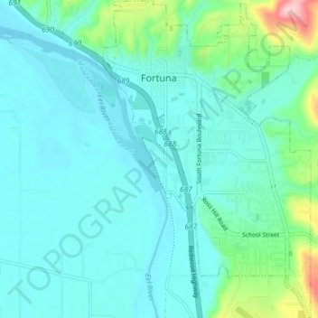
Name: Fortuna topographic map, elevation, terrain.

Location: Fortuna, Humboldt County, California, 95540, United States (40.55571 -124.16874 40.61087 -124.12124)

Average elevation: 64 m

Minimum elevation: -1 m

Maximum elevation: 270 m

Gear up for your next adventure:

💡LED Camping Lantern - Illuminate your campsite with long-lasting lanterns
👟Leg Gaiters - Keep debris, mud, and snow out of your boots
💧Collapsible Water Bottle - Space-saving water bottle for outdoor activities
🥾Lightweight Hiking Shoes - Comfortable shoes for day hikes
🧥Thermal Fleece Jacket - Versatile insulation for changing mountain temperatures

As an Amazon Associate, this site earns from qualifying purchases at no extra cost to you.