
Make a donation
Gear up for your next adventure:
As an Amazon Associate, this site earns from qualifying purchases at no extra cost to you.
Taylorsville topographic map
Click on the map to display elevation.
Make a donation
Gear up for your next adventure:
As an Amazon Associate, this site earns from qualifying purchases at no extra cost to you.
Taylorsville
The land on which Taylorsville is located is part of an interconnected alluvial plain that was formed by the wearing down of the Wasatch and Oquirrh Mountains to the east and west. Beneath the surface, Taylorsville sits on more than a kilometer of unconsolidated rock, sand, and clay. The inactive Taylorsville Fault has been traced down the center of the Salt Lake Valley. Lake Bonneville shaped the topography of the area and deposited lake bottom clay and sand. As Lake Bonneville dried up over the past 14,000 years, the salt from the breakdown of rock remains, making the soil alkaline. Like most desert soils, it has little organic material and is hard to work.
Make a donation
Gear up for your next adventure:
As an Amazon Associate, this site earns from qualifying purchases at no extra cost to you.
About this map
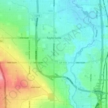
Name: Taylorsville topographic map, elevation, terrain.
Location: Taylorsville, Salt Lake County, Utah, United States (40.62985 -111.99155 40.68633 -111.90783)
Average elevation: 1,325 m
Minimum elevation: 1,293 m
Maximum elevation: 1,410 m
Make a donation
Gear up for your next adventure:
As an Amazon Associate, this site earns from qualifying purchases at no extra cost to you.
Other topographic maps
Click on a map to view its topography, its elevation and its terrain.
Jordan River OHV/ Modelport State Park
United States > Utah > Salt Lake County > Salt Lake City
Average elevation: 1,286 m
Make a donation
Gear up for your next adventure:
As an Amazon Associate, this site earns from qualifying purchases at no extra cost to you.
Make a donation
Gear up for your next adventure:
As an Amazon Associate, this site earns from qualifying purchases at no extra cost to you.
Salt Lake City
United States > Utah > Salt Lake County > Salt Lake City
Salt Lake City has an area of 110.4 square miles (286 km2) and an average elevation of 4,327 feet (1,319 m) above sea level. The lowest point within the boundaries of the city is 4,210 feet (1,280 m) near the Jordan River and the Great Salt Lake, and the highest is Grandview Peak, at 9,410 feet (2,868 m).
Average elevation: 1,625 m
Make a donation
Gear up for your next adventure:
As an Amazon Associate, this site earns from qualifying purchases at no extra cost to you.
Make a donation
Gear up for your next adventure:
As an Amazon Associate, this site earns from qualifying purchases at no extra cost to you.
Make a donation
Gear up for your next adventure:
As an Amazon Associate, this site earns from qualifying purchases at no extra cost to you.
Riverton Majestic Village
United States > Utah > Salt Lake County > Riverton
Average elevation: 1,369 m
Meridian Peak
United States > Utah > Salt Lake County > Salt Lake City
Meridian Peak can be found at the southern end of Elliot Ridge Trail. It can be reached by ascending several hiking trails into the Gore Range. Surprise Lake Trail goes south for 2.6 miles to Surprise Lake, then the Gore Range Trail continues west for 1.9 miles to a junction with the Upper Cataract Lake and…
Average elevation: 1,698 m
Make a donation
Gear up for your next adventure:
As an Amazon Associate, this site earns from qualifying purchases at no extra cost to you.
Brighton
United States > Utah > Salt Lake County
Brighton has a high-altitude cold continental climate (Köppen Dsb/Dsc), with dry summers and very snowy winters.
Average elevation: 2,852 m
Make a donation
Gear up for your next adventure:
As an Amazon Associate, this site earns from qualifying purchases at no extra cost to you.
Silver Lake Summer Resort
United States > Utah > Salt Lake County > Brighton
Average elevation: 2,833 m