Geolocate

Meesapulimala topographic map

Click on the map to display elevation.

About this map

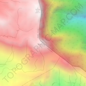
Name: Meesapulimala topographic map, elevation, terrain.

Location: Meesapulimala, Devikulam, Idukki, Kerala, India (10.08751 77.20438 10.08761 77.20448)

Average elevation: 2,228 m

Minimum elevation: 1,425 m

Maximum elevation: 2,643 m

Other topographic maps

Click on a map to view its topography, its elevation and its terrain.

Viripara

India > Kerala > Devikulam

Average elevation: 1,143 m

Pallivasal

India > Kerala > Devikulam > Pallivasal

Average elevation: 1,304 m

Pothupara

India > Kerala > Devikulam > Ellakkal

Average elevation: 769 m

Thalamali

India > Kerala > Devikulam > Adimali

Average elevation: 885 m

Anaimudi River

India > Kerala > Devikulam

Average elevation: 1,430 m

Mattupetty Dam

India > Kerala > Devikulam > Mattupetty

Average elevation: 1,665 m

Anamalai

India > Kerala > Devikulam

Average elevation: 2,023 m

Eravikulam National Park

India > Kerala > Devikulam > Lakkomukudi

Average elevation: 1,701 m

Gear up for your next adventure:

💧Filtered Water Bottle - Safe drinking water on the go
🧥Softshell Hiking Jacket - The perfect balance of wind protection and breathability
🛶Canoe Life Vest - Safety vest for water sports
❄️Traction Ice Cleats - Slip-on spikes for icy trails and winter hiking
Camping Essentials - All-in-one gear for a comfortable camping trip

As an Amazon Associate, this site earns from qualifying purchases at no extra cost to you.