Geolocate

Pallivasal topographic map

Click on the map to display elevation.

About this map

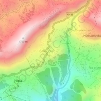
Name: Pallivasal topographic map, elevation, terrain.

Location: Pallivasal, Devikulam, Idukki District, Kerala, India (10.03316 77.04002 10.06651 77.06293)

Average elevation: 1,304 m

Minimum elevation: 843 m

Maximum elevation: 1,755 m

Other topographic maps

Click on a map to view its topography, its elevation and its terrain.

Attukad waterfall

India > Kerala > Devikulam > Pallivasal

Average elevation: 1,334 m

Hill Top View Point

India > Kerala > Devikulam > Pallivasal

Average elevation: 1,443 m

Attukad waterfall

India > Kerala > Devikulam > Pallivasal

Average elevation: 1,334 m

Gear up for your next adventure:

🚲Bike Repair Kit - Essential tools for on-trail mechanical issues
💡Compact LED Flashlight - Powerful and portable flashlight for outdoor use
🧥Insulated Jacket - Keep warm in cold outdoor conditions
💧Hydration Pack - Hands-free hydration system for long hikes
🦟Insect Repellent - Keep mosquitoes and black flies away in wooded areas

As an Amazon Associate, this site earns from qualifying purchases at no extra cost to you.