Geolocate

Torrey topographic map

Click on the map to display elevation.

About this map

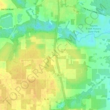
Name: Torrey topographic map, elevation, terrain.

Location: Torrey, Hardee County, Florida, United States (27.59087 -81.84619 27.63087 -81.80619)

Average elevation: 29 m

Minimum elevation: 14 m

Maximum elevation: 41 m

Other topographic maps

Click on a map to view its topography, its elevation and its terrain.

Wauchula

United States > Florida > Hardee County

Average elevation: 30 m

Peace River

United States > Florida > Hardee County

Average elevation: 25 m

Bowling Green

United States > Florida > Hardee County

Average elevation: 31 m

Zolfo Springs

United States > Florida > Hardee County

Average elevation: 20 m

Zolfo Springs

United States > Florida > Hardee County

Average elevation: 20 m

Bowling Green

United States > Florida > Hardee County

Average elevation: 31 m

Gear up for your next adventure:

Camping Tent - Weather-resistant tents suitable for 2 to 6 people
🔭Outdoor Binoculars - Lightweight binoculars for birdwatching and hiking
🌬️Windproof Camp Stove - Efficient cooking even on exposed mountain peaks
Family Camping Tent - Spacious tent suitable for family camping trips
🧥Ultralight Puffy Jacket - Maximum warmth that packs down to the size of an orange

As an Amazon Associate, this site earns from qualifying purchases at no extra cost to you.