
Make a donation
Gear up for your next adventure:
As an Amazon Associate, this site earns from qualifying purchases at no extra cost to you.
Catoctin Mountain topographic map
Click on the map to display elevation.
Make a donation
Gear up for your next adventure:
As an Amazon Associate, this site earns from qualifying purchases at no extra cost to you.
Catoctin Mountain
Catoctin Mountain traverses Frederick County, Maryland and extends into northern Loudoun County, Virginia. It rises to its greatest elevation of 1,900 feet (580 m) above sea level just southwest of Cunningham Falls State Park and is transected by gaps at Braddock Heights (Fairview Pass), Point of Rocks on the Potomac River and Clarke's Gap west of Leesburg, as well as several other unnamed passes in Maryland and Virginia. The mountain is much lower in elevation in Virginia, reaching its highest peak just south of the Potomac at Furnace Mountain (891 feet/271 m) and with only one peak above 800 feet (240 m) south of Leesburg.
Make a donation
Gear up for your next adventure:
As an Amazon Associate, this site earns from qualifying purchases at no extra cost to you.
About this map
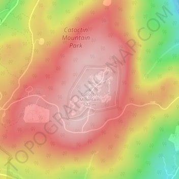
Name: Catoctin Mountain topographic map, elevation, terrain.
Average elevation: 471 m
Minimum elevation: 271 m
Maximum elevation: 574 m
Make a donation
Gear up for your next adventure:
As an Amazon Associate, this site earns from qualifying purchases at no extra cost to you.
Other topographic maps
Click on a map to view its topography, its elevation and its terrain.
Make a donation
Gear up for your next adventure:
As an Amazon Associate, this site earns from qualifying purchases at no extra cost to you.
Braddock Heights
United States > Maryland > Frederick County > Braddock Heights
Braddock Heights is located at an elevation of 950 feet (290 m) atop Braddock Mountain (as Catoctin Mountain is locally known) near the pass at Braddock Springs, so named after British General Edward Braddock and Lt. Colonel George Washington's use of the mountain pass on their way to Fort Duquesne during the…
Average elevation: 179 m
Make a donation
Gear up for your next adventure:
As an Amazon Associate, this site earns from qualifying purchases at no extra cost to you.
Make a donation
Gear up for your next adventure:
As an Amazon Associate, this site earns from qualifying purchases at no extra cost to you.
Make a donation
Gear up for your next adventure:
As an Amazon Associate, this site earns from qualifying purchases at no extra cost to you.
Make a donation
Gear up for your next adventure:
As an Amazon Associate, this site earns from qualifying purchases at no extra cost to you.
Make a donation
Gear up for your next adventure:
As an Amazon Associate, this site earns from qualifying purchases at no extra cost to you.
Make a donation
Gear up for your next adventure:
As an Amazon Associate, this site earns from qualifying purchases at no extra cost to you.