Geolocate

Monroe County topographic map

Click on the map to display elevation.

About this map

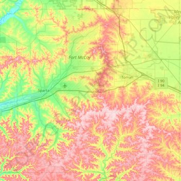
Name: Monroe County topographic map, elevation, terrain.

Location: Monroe County, Wisconsin, United States (43.72526 -90.97842 44.16105 -90.31148)

Average elevation: 320 m

Minimum elevation: 215 m

Maximum elevation: 443 m

Other topographic maps

Click on a map to view its topography, its elevation and its terrain.

Shennington

United States > Wisconsin > Monroe County

Average elevation: 278 m

Gear up for your next adventure:

Family Camping Tent - Spacious tent suitable for family camping trips
🥾All-Terrain Hiking Boots - Versatile boots for varied hiking conditions
👖Convertible Hiking Pants - Zip-off legs to adapt to changing weather conditions
Lightweight Camping Tent - Portable shelter optimized for Canadian backcountry camping
🧦Merino Wool Socks - Moisture-wicking comfort for long-distance hiking

As an Amazon Associate, this site earns from qualifying purchases at no extra cost to you.