
Make a donation
Gear up for your next adventure:
As an Amazon Associate, this site earns from qualifying purchases at no extra cost to you.
Outer Nanaimo Harbour topographic map
Click on the map to display elevation.
Make a donation
Gear up for your next adventure:
As an Amazon Associate, this site earns from qualifying purchases at no extra cost to you.
About this map
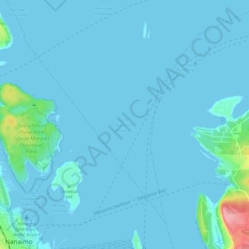
Name: Outer Nanaimo Harbour topographic map, elevation, terrain.
Average elevation: 7 m
Minimum elevation: -1 m
Maximum elevation: 110 m
Regional District of Nanaimo trails, hiking, mountain biking, running and outdoor activities
Make a donation
Gear up for your next adventure:
As an Amazon Associate, this site earns from qualifying purchases at no extra cost to you.
Other topographic maps
Click on a map to view its topography, its elevation and its terrain.
Cathers Lake
Canada > British Columbia > Regional District of Nanaimo > Nanaimo
Average elevation: 119 m
East Wellington Park
Canada > British Columbia > Regional District of Nanaimo > Nanaimo
Average elevation: 99 m
Colinwood Park
Canada > British Columbia > Regional District of Nanaimo > Nanaimo
Average elevation: 104 m
Make a donation
Gear up for your next adventure:
As an Amazon Associate, this site earns from qualifying purchases at no extra cost to you.