Geolocate

Kailash topographic map

Click on the map to display elevation.

About this map

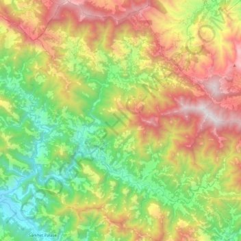
Name: Kailash topographic map, elevation, terrain.

Location: Kailash, Makwanpur, Bagamati Province, Nepal (27.51870 84.87555 27.69856 85.03491)

Average elevation: 1,270 m

Minimum elevation: 348 m

Maximum elevation: 2,554 m

Other topographic maps

Click on a map to view its topography, its elevation and its terrain.

Hetauda

Nepal > Bagamati Province > Makwanpur

Average elevation: 789 m

Dumān

Nepal > Bagamati Province > Makwanpur

Average elevation: 1,901 m

Hetauda

Nepal > Bagamati Province > Makwanpur

Average elevation: 789 m

Phapung

Nepal > Bagamati Province > Makwanpur

Average elevation: 1,774 m

khayar ghari

Nepal > Bagamati Province > Makwanpur

Average elevation: 277 m

Hetauda

Nepal > Bagamati Province > Makwanpur

Average elevation: 789 m

Palung

Nepal > Bagamati Province > Makwanpur > Thaha

Average elevation: 1,941 m

Gear up for your next adventure:

🧭GPS Handheld Device - Reliable GPS navigation for outdoor adventures
🌡️Emergency Mylar Blankets - Compact thermal protection for unexpected nights outdoors
🥾Mountain Hiking Shoes - Shoes with superior grip for mountainous terrain
🗺️Topographic Maps - Detailed maps to explore trails, mountains, and wilderness areas
🧥Softshell Hiking Jacket - The perfect balance of wind protection and breathability

As an Amazon Associate, this site earns from qualifying purchases at no extra cost to you.