
Swithland topographic map
Click on the map to display elevation.
About this map
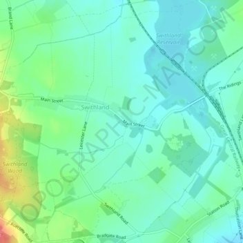
Name: Swithland topographic map, elevation, terrain.
Location: Swithland, Charnwood, Leicestershire, England, United Kingdom (52.69883 -1.20580 52.72337 -1.16418)
Average elevation: 74 m
Minimum elevation: 55 m
Maximum elevation: 128 m
Other topographic maps
Click on a map to view its topography, its elevation and its terrain.
Swithland Wood
United Kingdom > England > Leicestershire > Charnwood > Swithland
Average elevation: 107 m