
Biarritz topographic map
Click on the map to display elevation.
Biarritz
Biarritz appears as Bearids and Bearriz in 1150, Beiarridz in 1165, Bearriz and Beariz in 1170, Bearidz (1186), Bearriz and Beariz (12th century), lo port de Beiarriz and Bearridz in 1261 (cartulaire de Bayonne). Other forms include Beiarid (1199), Bearritz (1249), Beiarriz and Beiarrids (1261), Bearridz (1281), Bearrits (1338), (rôles gascons), Bearritz (1498, chapitre de Bayonne), Sanctus Martinus de Biarriz (1689, collations du diocèse de Bayonne, Mearritcen (1712), Biarrits (1863, Dictionnaire topographique Béarn-Pays basque), as well as Biarritze and Miarritze.
About this map
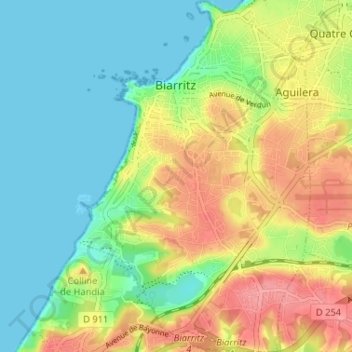
Name: Biarritz topographic map, elevation, terrain.
Average elevation: 34 m
Minimum elevation: 0 m
Maximum elevation: 87 m
Other topographic maps
Click on a map to view its topography, its elevation and its terrain.
Coustères
France > Nouvelle-Aquitaine > Pyrénées-Atlantiques > Salies-de-Béarn
Average elevation: 81 m
Izpegi
France > Nouvelle-Aquitaine > Pyrénées-Atlantiques > Saint-Étienne-de-Baïgorry
Average elevation: 632 m
Pic d'Orisson / Harburu
France > Nouvelle-Aquitaine > Pyrénées-Atlantiques > Saint-Michel
Average elevation: 817 m
Château-Observatoire Abbadia
France > Nouvelle-Aquitaine > Pyrénées-Atlantiques > Hendaye > Sopite
Average elevation: 25 m
Pic d'Orisson / Harburu
France > Nouvelle-Aquitaine > Pyrénées-Atlantiques > Saint-Michel
Average elevation: 817 m
Larroinea
France > Nouvelle-Aquitaine > Pyrénées-Atlantiques > Saint-Jean-Pied-de-Port
Average elevation: 204 m
Agerreko Larrea
France > Nouvelle-Aquitaine > Pyrénées-Atlantiques > Mouguerre
Average elevation: 39 m