Geolocate

Gin Gin topographic map

Click on the map to display elevation.

About this map

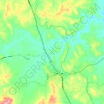
Name: Gin Gin topographic map, elevation, terrain.

Location: Gin Gin, Bundaberg Region, Queensland, 4671, Australia (-25.01469 151.90965 -24.93927 151.99505)

Average elevation: 74 m

Minimum elevation: 28 m

Maximum elevation: 168 m

Other topographic maps

Click on a map to view its topography, its elevation and its terrain.

Gin Gin

Australia > Queensland > Bundaberg Region > Gin Gin

Average elevation: 73 m

Gear up for your next adventure:

❄️Traction Ice Cleats - Slip-on spikes for icy trails and winter hiking
🧭GPS Tracker - Track your location in remote areas safely
🧣Merino Neck Gaiter - Protects against wind, sun, and cold at high altitudes
🦯Trekking Poles - Reduced impact on joints for steep topographic climbs
👟Leg Gaiters - Keep debris, mud, and snow out of your boots

As an Amazon Associate, this site earns from qualifying purchases at no extra cost to you.