
Hunza District topographic map
Click on the map to display elevation.
About this map
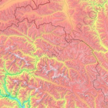
Name: Hunza District topographic map, elevation, terrain.
Location: Hunza District, Gilgit Division, Gilgit-Baltistan, Pakistan (36.01356 74.04558 37.08411 76.06198)
Average elevation: 4,510 m
Minimum elevation: 1,379 m
Maximum elevation: 7,721 m
Other topographic maps
Click on a map to view its topography, its elevation and its terrain.
Nanga Parbat
Pakistan > Gilgit-Baltistan > Astore District
To the south, Nanga Parbat has what is often referred to as the highest mountain face in the world: the Rupal Face rises 4,600 m (15,090 ft) above its base. To the north, the complex, somewhat more gently-sloped Rakhiot Flank rises 7,000 m (23,000 ft) from the Indus River valley to the summit in just 25 km (16…
Average elevation: 7,086 m