
Make a donation
Gear up for your next adventure:
As an Amazon Associate, this site earns from qualifying purchases at no extra cost to you.
Mendenhall Glacier topographic map
Click on the map to display elevation.
Make a donation
Gear up for your next adventure:
As an Amazon Associate, this site earns from qualifying purchases at no extra cost to you.
Mendenhall Glacier
The two small parking lots have access to several trails in the area. Photo Point Trail and the Steep Creek Trail are easy and accessible trails. Elevated boardwalks above Steep Creek provide salmon and bear viewing opportunities. Visitors can hike via the East Glacier Loop to an overlook within 1 mile (1,600 m) of the glacier. Two routes traverse a series of wooden steps and a gradual elevation gain of 500 feet (150 m) on this trail. The Trail of Time, which connects to East Glacier Loop, includes historical signs and handicapped accessibility. The 0.8 miles (1,300 m) Nugget Falls Trail leads visitors to Nugget Falls, closer to the face of the glacier. Access to the outside area and trails is free. The West Glacier trail offers access to the glacier itself and the chance to view ice caves beneath it. This trail is located across the lake from the Visitor Center.
Make a donation
Gear up for your next adventure:
As an Amazon Associate, this site earns from qualifying purchases at no extra cost to you.
About this map
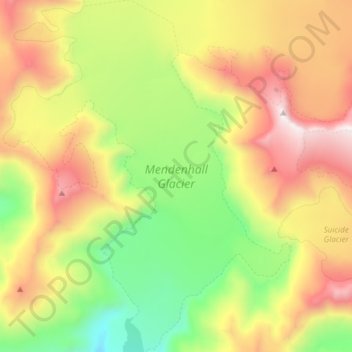
Name: Mendenhall Glacier topographic map, elevation, terrain.
Location: Mendenhall Glacier, Juneau, Alaska, United States (58.43765 -134.60510 58.57199 -134.42573)
Average elevation: 974 m
Minimum elevation: 86 m
Maximum elevation: 1,992 m
Make a donation
Gear up for your next adventure:
As an Amazon Associate, this site earns from qualifying purchases at no extra cost to you.