Geolocate

Creton topographic map

Click on the map to display elevation.

About this map

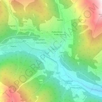
Name: Creton topographic map, elevation, terrain.

Location: Creton, Étroubles, Aosta Valley, 11014, Italy (45.80128 7.21406 45.84128 7.25406)

Average elevation: 1,681 m

Minimum elevation: 1,095 m

Maximum elevation: 2,709 m

Other topographic maps

Click on a map to view its topography, its elevation and its terrain.

Morgex

Italy > Aosta Valley

Average elevation: 1,818 m

Ollomont

Italy > Aosta Valley

Average elevation: 2,458 m

Saint-Rhémy-en-Bosses

Italy > Aosta Valley

Average elevation: 2,181 m

Paquier

Italy > Aosta Valley > Saint-Marcel

Average elevation: 718 m

Saint-Marcel

Italy > Aosta Valley

Average elevation: 1,962 m

Castello Gamba

Italy > Aosta Valley > Châtillon > Sétoret

Average elevation: 687 m

Torgnon

Italy > Aosta Valley

Average elevation: 1,963 m

Saint-Denis

Italy > Aosta Valley

Average elevation: 1,084 m

Pré-Saint-Didier

Italy > Aosta Valley

Average elevation: 1,795 m

Lago di Place Moulin

Italy > Aosta Valley

Average elevation: 2,297 m

Saint-Vincent

Italy > Aosta Valley

Saint-Vincent (Valdôtain: Sèn-Veuncein; Issime Walser: Finze) is a town and comune in the Aosta Valley region of north-western Italy. Saint-Vincent, elevation 575 metres (1,886 ft), is a popular summer holiday resort with mineral springs.

Average elevation: 1,179 m

Gear up for your next adventure:

🌡️Emergency Mylar Blankets - Compact thermal protection for unexpected nights outdoors
🛌Down Sleeping Bag - Superior warmth-to-weight ratio for cold nights
🧭GPS Outdoor Watch - Smart watch for navigation and fitness tracking in nature
🧴Bear Spray Holster - Quick-access carry for essential Canadian wilderness safety
🥾Light Trekking Boots - Supportive boots for multi-day treks

As an Amazon Associate, this site earns from qualifying purchases at no extra cost to you.