
Antioch topographic map
Click on the map to display elevation.
About this map
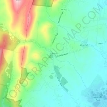
Name: Antioch topographic map, elevation, terrain.
Location: Antioch, Prince William County, Virginia, United States (38.83911 -77.70613 38.87911 -77.66613)
Average elevation: 199 m
Minimum elevation: 119 m
Maximum elevation: 381 m
Other topographic maps
Click on a map to view its topography, its elevation and its terrain.
Manassas National Battlefield Park
United States > Virginia > Prince William County
Average elevation: 74 m
Prince William Forest Park
United States > Virginia > Prince William County > Triangle
Average elevation: 81 m
Bull Run Mountain Estates
United States > Virginia > Prince William County > Bull Run Mountain Estates
Average elevation: 201 m
County Center
United States > Virginia > Prince William County > County Center
Average elevation: 91 m
Manassas National Battlefield Park
United States > Virginia > Prince William County
Average elevation: 74 m
Quantico Base
United States > Virginia > Prince William County > Quantico Base
Average elevation: 23 m
Bull Run Mountain Estates
United States > Virginia > Prince William County > Bull Run Mountain Estates
Average elevation: 205 m