Geolocate

Agate topographic map

Click on the map to display elevation.

About this map
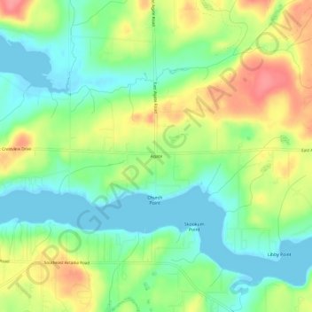
Name: Agate topographic map, elevation, terrain.

Location: Agate, Mason County, Washington, United States (47.19343 -123.03237 47.23343 -122.99237)

Average elevation: 32 m

Minimum elevation: -4 m

Maximum elevation: 81 m

Other topographic maps

Click on a map to view its topography, its elevation and its terrain.

Shelton

United States > Washington > Mason County

Average elevation: 54 m

Allyn

United States > Washington > Mason County > Allyn

Average elevation: 47 m

Belfair

United States > Washington > Mason County

Average elevation: 65 m

Oakland Bay

United States > Washington > Mason County > Shelton

Average elevation: 36 m

Price Lake

United States > Washington > Mason County

Average elevation: 326 m

Grapeview

United States > Washington > Mason County

Average elevation: 17 m

Shelton

United States > Washington > Mason County

Average elevation: 54 m

Lake Cushman

United States > Washington > Mason County

Average elevation: 410 m

Allyn

United States > Washington > Mason County > Allyn

Average elevation: 47 m

Belfair

United States > Washington > Mason County

Average elevation: 65 m

Gear up for your next adventure:

❄️Traction Ice Cleats - Slip-on spikes for icy trails and winter hiking
🧭GPS Handheld Device - Reliable GPS navigation for outdoor adventures
🪜Heavy Duty Carabiners - Multi-use clips for securing gear to your backpack
🥾Waterproof Hiking Boots - Boots keeping your feet dry in wet conditions
🥾Trail Hiking Socks - Comfortable socks to prevent blisters and fatigue

As an Amazon Associate, this site earns from qualifying purchases at no extra cost to you.