
Traunstein topographic map
Click on the map to display elevation.
About this map
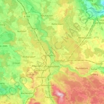
Name: Traunstein topographic map, elevation, terrain.
Location: Traunstein, Landkreis Traunstein, Bavaria, 83278, Germany (47.83208 12.57859 47.93710 12.70266)
Average elevation: 601 m
Minimum elevation: 468 m
Maximum elevation: 774 m
Other topographic maps
Click on a map to view its topography, its elevation and its terrain.
Waginger See
Germany > Bavaria > Landkreis Traunstein > Waginger See > Fisching
Waginger See is a lake in the Alpine foothills, Bavaria, Germany. Geologically, it forms one single lake with the Tachinger See, with which it is connected through a narrow strait at Tettenhausen. The surface area of the Waginger See proper is 6.61 km2 (2.55 sq mi); combined with the Tachinger See it is 8.97…
Average elevation: 464 m