
Waginger See topographic map
Click on the map to display elevation.
Waginger See
Waginger See is a lake in the Alpine foothills, Bavaria, Germany. Geologically, it forms one single lake with the Tachinger See, with which it is connected through a narrow strait at Tettenhausen. The surface area of the Waginger See proper is 6.61 km2 (2.55 sq mi); combined with the Tachinger See it is 8.97 km2 (3.46 sq mi). Its elevation is 441 m (1,447 ft) and its drainage area is 163.66 km2 (63.19 sq mi). Its primary inflows are Schinderbach, Höllenbach and Tenglinger Bach, and it is drained by the Götzinger Achen.
About this map
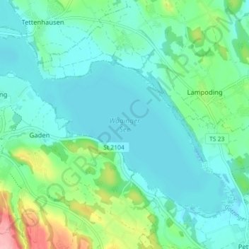
Name: Waginger See topographic map, elevation, terrain.
Average elevation: 464 m
Minimum elevation: 437 m
Maximum elevation: 565 m