Geolocate

Denekamp topographic map

Click on the map to display elevation.

About this map

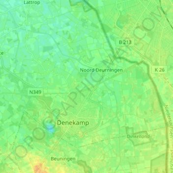
Name: Denekamp topographic map, elevation, terrain.

Location: Denekamp, Dinkelland, Overijssel, Netherlands (52.36383 6.94946 52.41506 7.07220)

Average elevation: 25 m

Minimum elevation: 16 m

Maximum elevation: 41 m

Other topographic maps

Click on a map to view its topography, its elevation and its terrain.

Lemelerberg

Netherlands > Overijssel > Lemele

Average elevation: 19 m

Enschede

Netherlands > Overijssel > Enschede

Average elevation: 34 m

Zuurberg

Netherlands > Overijssel > Holten

Average elevation: 17 m

Frankhuis

Netherlands > Overijssel > Zwolle

Average elevation: 3 m

Witteberg

Netherlands > Overijssel

Average elevation: 57 m

Tankenberg

Netherlands > Overijssel > de Lutte

Average elevation: 58 m

Usselo

Netherlands > Overijssel > Enschede

Average elevation: 31 m

Helhuizen

Netherlands > Overijssel > Holten

Average elevation: 20 m

Gear up for your next adventure:

🧼Travel Hand Sanitizer - Keep hands clean when water is scarce
Backpacking Tent - Lightweight tent for long-distance hiking trips
🧥Waterproof Jacket - Lightweight rain jackets for hiking and outdoor activities
🥾Waterproof Hiking Shoes - Durable shoes for wet and rugged trails
🚲MTB Frame Bag - Carry tools and maps directly on your bicycle frame

As an Amazon Associate, this site earns from qualifying purchases at no extra cost to you.