Geolocate

Paligawan topographic map

Click on the map to display elevation.

About this map

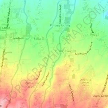
Name: Paligawan topographic map, elevation, terrain.

Location: Paligawan, Silang, Cavite, Calabarzon, 4118, Philippines (14.15752 120.95992 14.19752 120.99992)

Average elevation: 413 m

Minimum elevation: 341 m

Maximum elevation: 491 m

Other topographic maps

Click on a map to view its topography, its elevation and its terrain.

Carmen

Philippines > Cavite > Silang

Average elevation: 172 m

Carmen

Philippines > Cavite > Silang

Average elevation: 172 m

Gear up for your next adventure:

🥾Mountain Hiking Boots - High-traction boots for rocky terrain
🌬️Windproof Camp Stove - Efficient cooking even on exposed mountain peaks
👖Convertible Hiking Pants - Zip-off legs to adapt to changing weather conditions
🧥Thermal Layer - Insulating layer for cold outdoor conditions
🥾Approach Boots - Comfortable boots for hiking and climbing approaches

As an Amazon Associate, this site earns from qualifying purchases at no extra cost to you.