
Lakewood topographic map
Click on the map to display elevation.
About this map
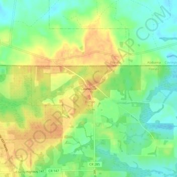
Name: Lakewood topographic map, elevation, terrain.
Location: Lakewood, Walton County, Florida, 32538, United States (30.96860 -86.30189 31.00860 -86.26189)
Average elevation: 89 m
Minimum elevation: 69 m
Maximum elevation: 109 m
Other topographic maps
Click on a map to view its topography, its elevation and its terrain.
Paxton
United States > Florida > Walton County
Paxton is a town in Walton County, Florida, United States. The population was 644 as of the 2010 census. Located near Britton Hill on the Alabama–Florida state line, the town has the highest elevation of any in Florida.
Average elevation: 82 m
Paxton
United States > Florida > Walton County
Paxton is a town in Walton County, Florida, United States. Located near Britton Hill on the Alabama–Florida state line, it has the highest elevation of any in Florida. The Town of Paxton is located on the Florida Panhandle, and is part of the Crestview–Fort Walton Beach–Destin, Florida Metropolitan…
Average elevation: 82 m
Choctaw Beach Community Center Park
United States > Florida > Walton County > Freeport > Choctaw Beach
Average elevation: 7 m