Geolocate

Miramar Beach topographic map

Click on the map to display elevation.

About this map

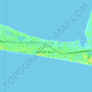
Name: Miramar Beach topographic map, elevation, terrain.

Location: Miramar Beach, Walton County, Florida, United States (30.36665 -86.39732 30.39826 -86.31711)

Average elevation: 2 m

Minimum elevation: -1 m

Maximum elevation: 19 m

Other topographic maps

Click on a map to view its topography, its elevation and its terrain.

Gear up for your next adventure:

👟Leg Gaiters - Keep debris, mud, and snow out of your boots
🔥Camping Stove - Portable stoves to cook outdoors with ease
🧥Packable Rain Jacket - Breathable waterproof layer for unpredictable weather
🎒Hiking Backpack - Lightweight and ergonomic backpacks for day hikes or multi-day treks
🥾Mountain Hiking Shoes - Shoes with superior grip for mountainous terrain

As an Amazon Associate, this site earns from qualifying purchases at no extra cost to you.