
North Rim topographic map
Interactive map
Click on the map to display elevation.
About this map
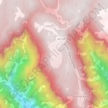
Name: North Rim topographic map, elevation, terrain.
Location: North Rim, Coconino County, Arizona, United States (36.20044 -112.07107 36.22044 -112.05107)
Average elevation: 2,297 m
Minimum elevation: 1,574 m
Maximum elevation: 2,556 m
Other topographic maps
Click on a map to view its topography, its elevation and its terrain.
Darling
United States > Arizona > Coconino County
Darling, Coconino County, Arizona, United States
Average elevation: 1,916 m
Roden Crater
United States > Arizona > Coconino County
Roden Crater, Coconino County, Arizona, United States
Average elevation: 1,497 m
Page
United States > Arizona > Coconino County
Page, Coconino County, Arizona, United States
Average elevation: 1,225 m
Munds Park
United States > Arizona > Coconino County
Munds Park, Coconino County, Arizona, 86017, United States
Average elevation: 2,049 m
Kachina Village
United States > Arizona > Coconino County > Kachina Village
Kachina Village, Coconino County, Arizona, United States
Average elevation: 2,076 m
Grand Canyon Village
United States > Arizona > Coconino County
Grand Canyon Village, Coconino County, Arizona, United States
Average elevation: 1,778 m
Glen Canyon
United States > Arizona > Coconino County
Glen Canyon, Coconino County, Arizona, 86040-0418, United States
Average elevation: 1,248 m
Happy Jack
United States > Arizona > Coconino County > Happy Jack
Happy Jack, Coconino County, Arizona, United States
Average elevation: 2,284 m
Flagstaff
United States > Arizona > Coconino County
Flagstaff, Coconino County, Arizona, United States
Average elevation: 2,176 m
Grand Canyon
United States > Arizona > Coconino County
Grand Canyon, Coconino County, Arizona, United States
Average elevation: 1,021 m