
Zellik topographic map
Interactive map
Click on the map to display elevation.
About this map
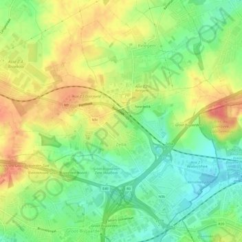
Name: Zellik topographic map, elevation, terrain.
Location: Zellik, Asse, Hal-Vilvorde, Brabant flamand, Flandre, Belgique (50.87344 4.24052 50.90232 4.30094)
Average elevation: 56 m
Minimum elevation: 28 m
Maximum elevation: 87 m
Other topographic maps
Click on a map to view its topography, its elevation and its terrain.
Mollem
Belgique > Brabant flamand > Hal-Vilvorde > Asse
Mollem, Asse, Hal-Vilvorde, Brabant flamand, Belgique
Average elevation: 50 m