Geolocate

Comatrana topographic map

Click on the map to display elevation.

About this map

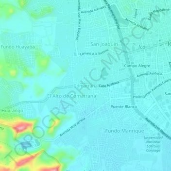
Name: Comatrana topographic map, elevation, terrain.

Location: Comatrana, Ica, 11001, Perú (-14.09397 -75.76974 -14.05397 -75.72974)

Average elevation: 412 m

Minimum elevation: 394 m

Maximum elevation: 524 m

Other topographic maps

Click on a map to view its topography, its elevation and its terrain.

Huacachina

Perú > Ica > Ica > Huacachina

Average elevation: 439 m

Plaza de Armas de Ica

Perú > Ica > Ica

Average elevation: 409 m

Parque del Amor

Perú > Ica > Ica

Average elevation: 408 m

Plaza de Armas de Ica

Perú > Ica > Ica

Average elevation: 409 m

Huacachina

Perú > Ica > Ica > Huacachina

Average elevation: 439 m

Cachiche

Perú > Ica > Ica

Average elevation: 398 m

Gear up for your next adventure:

🧥Insulated Jacket - Keep warm in cold outdoor conditions
🧤Rechargeable Heated Gloves - Extreme warmth for Canadian winter expeditions
🪜Heavy Duty Carabiners - Multi-use clips for securing gear to your backpack
🥾Waterproof Hiking Boots - Essential footwear for rugged terrain and wet Canadian trails
🦯Trekking Poles - Reduced impact on joints for steep topographic climbs

As an Amazon Associate, this site earns from qualifying purchases at no extra cost to you.