Geolocate

Koronadal topographic map

Click on the map to display elevation.

About this map

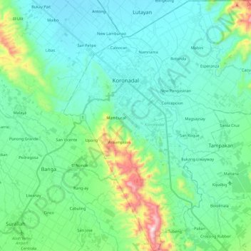
Name: Koronadal topographic map, elevation, terrain.

Location: Koronadal, South Cotabato, Soccsksargen, 9506, Philippines (6.35177 124.78885 6.56980 125.00042)

Average elevation: 164 m

Minimum elevation: 13 m

Maximum elevation: 808 m

Other topographic maps

Click on a map to view its topography, its elevation and its terrain.

Tampakan

Philippines > South Cotabato

Average elevation: 142 m

Bukay Pait

Philippines > South Cotabato

Average elevation: 39 m

Desawo

Philippines > South Cotabato

Average elevation: 680 m

Gear up for your next adventure:

🛏️Camping Sleeping Mat - Comfortable mats for sleeping outdoors
🍽️Titanium Camping Spork - Ultralight and indestructible eating utensil
🎒Hiking Daypack - Lightweight and durable backpacks for day trips and excursions
🥾Lightweight Hiking Boots - Boots for comfort and mobility on long hikes
🛶Kayak Accessories - Essential gear for safe and fun kayaking adventures

As an Amazon Associate, this site earns from qualifying purchases at no extra cost to you.