Geolocate

Gungolding topographic map

Click on the map to display elevation.

About this map
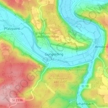
Name: Gungolding topographic map, elevation, terrain.

Location: Gungolding, Walting, Eichstätt (VGem), Landkreis Eichstätt, Bavaria, 85137, Germany (48.90442 11.32951 48.94442 11.36951)

Average elevation: 441 m

Minimum elevation: 373 m

Maximum elevation: 543 m

Other topographic maps

Click on a map to view its topography, its elevation and its terrain.

Altmannstein

Germany > Bavaria > Landkreis Eichstätt

Average elevation: 445 m

Beilngries

Germany > Bavaria > Landkreis Eichstätt

Average elevation: 480 m

Eichstätt

Germany > Bavaria > Landkreis Eichstätt

Average elevation: 490 m

Pförring

Germany > Bavaria > Landkreis Eichstätt

Average elevation: 381 m

Großmehring

Germany > Bavaria > Landkreis Eichstätt

Average elevation: 380 m

Kösching

Germany > Bavaria > Landkreis Eichstätt

Average elevation: 436 m

93336

Germany > Bavaria > Landkreis Eichstätt > Sandersdorf

Average elevation: 445 m

Eichstätt

Germany > Bavaria > Landkreis Eichstätt

Average elevation: 490 m

Gear up for your next adventure:

🧥Insulated Jacket - Keep warm in cold outdoor conditions
🛶Kayak Accessories - Essential gear for safe and fun kayaking adventures
🥾Lightweight Hiking Boots - Boots for comfort and mobility on long hikes
🦶Hiking Shoe Insoles - Added support for high arches and long days on feet
🥾Waterproof Hiking Boots - Boots keeping your feet dry in wet conditions

As an Amazon Associate, this site earns from qualifying purchases at no extra cost to you.