Geolocate

Großmehring topographic map

Click on the map to display elevation.

About this map

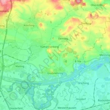
Name: Großmehring topographic map, elevation, terrain.

Location: Großmehring, Landkreis Eichstätt, Bavaria, 85098, Germany (48.73272 11.48919 48.83351 11.60506)

Average elevation: 380 m

Minimum elevation: 348 m

Maximum elevation: 465 m

Other topographic maps

Click on a map to view its topography, its elevation and its terrain.

Schamhaupten

Germany > Bavaria > Landkreis Eichstätt

Average elevation: 460 m

Gungolding

Germany > Bavaria > Landkreis Eichstätt

Average elevation: 441 m

Preith

Germany > Bavaria > Landkreis Eichstätt

Average elevation: 531 m

Gear up for your next adventure:

🛌Insulated Sleeping Pad - Critical thermal barrier between you and the cold ground
🧥Thermal Fleece Jacket - Versatile insulation for changing mountain temperatures
🥾Trail Hiking Boots - Supportive boots for rough trails
🧥Waterproof Pants - Keep dry during rainy hiking conditions
🔋Emergency Crank Radio - Weather alerts and power without needing batteries

As an Amazon Associate, this site earns from qualifying purchases at no extra cost to you.