Geolocate

Kösching topographic map

Click on the map to display elevation.

About this map

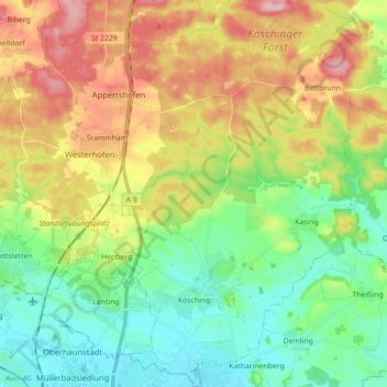
Name: Kösching topographic map, elevation, terrain.

Location: Kösching, Landkreis Eichstätt, Bavaria, 85092, Germany (48.78429 11.46846 48.90036 11.57093)

Average elevation: 436 m

Minimum elevation: 369 m

Maximum elevation: 544 m

Other topographic maps

Click on a map to view its topography, its elevation and its terrain.

Schamhaupten

Germany > Bavaria > Landkreis Eichstätt

Average elevation: 460 m

Gungolding

Germany > Bavaria > Landkreis Eichstätt

Average elevation: 441 m

Preith

Germany > Bavaria > Landkreis Eichstätt

Average elevation: 531 m

Gear up for your next adventure:

🎒Hiking Backpack - Lightweight and ergonomic backpacks for day hikes or multi-day treks
🧥Fleece Jacket - Warm and lightweight jacket for layering
🧰Emergency Multi-Tool - Compact multi-tool for outdoor survival
🥾Hiking Gaiters - Protect legs and shoes from mud, snow, and debris
🛏️Sleeping Bag - Warm and compact sleeping bags for outdoor camping

As an Amazon Associate, this site earns from qualifying purchases at no extra cost to you.