Geolocate

Ripon topographic map

Click on the map to display elevation.

About this map

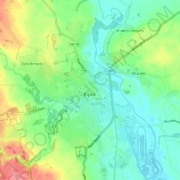
Name: Ripon topographic map, elevation, terrain.

Location: Ripon, North Yorkshire, England, United Kingdom (54.11993 -1.58757 54.15496 -1.49494)

Average elevation: 46 m

Minimum elevation: 14 m

Maximum elevation: 115 m

Other topographic maps

Click on a map to view its topography, its elevation and its terrain.

Coverdale

United Kingdom > England > North Yorkshire > Coverham

Average elevation: 379 m

Dalton Moor

United Kingdom > England > North Yorkshire > Dalton

Average elevation: 27 m

Water Houses

United Kingdom > England > North Yorkshire

Average elevation: 431 m

Hill

United Kingdom > England > North Yorkshire > Coniston Cold

Average elevation: 158 m

Osgodby

United Kingdom > England > North Yorkshire

Average elevation: 43 m

Harrogate

United Kingdom > England > North Yorkshire

Harrogate is situated on the edge of the Yorkshire Dales, with the Vale of York to the east and the upland Yorkshire Dales to the west and north-west. It has a dry and mild climate, typical of places in the rain shadow of the Pennines. It is on the A59 from Skipton to York. At an altitude of between 100 and…

Average elevation: 106 m

Reeth

United Kingdom > England > North Yorkshire > Reeth

Average elevation: 295 m

Hensall

United Kingdom > England > North Yorkshire > Selby

Average elevation: 9 m

Gear up for your next adventure:

👟Sport Hiking Sandals - Breathable footwear for water crossings and camp rest
🕯️Camping Lantern - Illuminates your entire campsite with high-efficiency LEDs
🛰️Satellite Messenger - Emergency communication for areas with no cell service
🧊Insulated Water Bottle - Keeps drinks cold in summer and prevents freezing in winter
🥽Outdoor Goggles - Protective eyewear for outdoor activities

As an Amazon Associate, this site earns from qualifying purchases at no extra cost to you.