
Make a donation
Gear up for your next adventure:
As an Amazon Associate, this site earns from qualifying purchases at no extra cost to you.
Bakkum topographic map
Click on the map to display elevation.
Make a donation
Gear up for your next adventure:
As an Amazon Associate, this site earns from qualifying purchases at no extra cost to you.
About this map
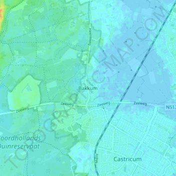
Name: Bakkum topographic map, elevation, terrain.
Location: Bakkum, Castricum, Noord-Holland, Nederland, 1901 MA, Nederland (52.54577 4.63477 52.58577 4.67477)
Average elevation: 3 m
Minimum elevation: -2 m
Maximum elevation: 27 m
Make a donation
Gear up for your next adventure:
As an Amazon Associate, this site earns from qualifying purchases at no extra cost to you.
Other topographic maps
Click on a map to view its topography, its elevation and its terrain.
Castricum
Nederland > Noord-Holland > Castricum
Topografisch kaartbeeld van de gemeente Castricum, per september 2022
Average elevation: 3 m
Make a donation
Gear up for your next adventure:
As an Amazon Associate, this site earns from qualifying purchases at no extra cost to you.
Make a donation
Gear up for your next adventure:
As an Amazon Associate, this site earns from qualifying purchases at no extra cost to you.