Geolocate

High Dubmire topographic map

Click on the map to display elevation.

About this map

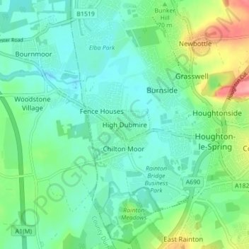
Name: High Dubmire topographic map, elevation, terrain.

Location: High Dubmire, Sunderland, Tyne and Wear, North East, England, DH4 5NF, United Kingdom (54.82333 -1.51521 54.86333 -1.47521)

Average elevation: 60 m

Minimum elevation: 34 m

Maximum elevation: 135 m

Other topographic maps

Click on a map to view its topography, its elevation and its terrain.

Washington

United Kingdom > England > Tyne and Wear > Sunderland

Average elevation: 64 m

Gear up for your next adventure:

🔋Emergency Crank Radio - Weather alerts and power without needing batteries
🔥Camping Stove - Portable stoves to cook outdoors with ease
🧦Outdoor Socks - Durable socks designed for hiking and outdoor sports
🩹Compact First Aid Kit - Pre-packed essentials for common trail injuries
🥾Hiking Shoes - Durable and comfortable shoes for trail hiking

As an Amazon Associate, this site earns from qualifying purchases at no extra cost to you.