Geolocate

Buntingford topographic map

Click on the map to display elevation.

About this map

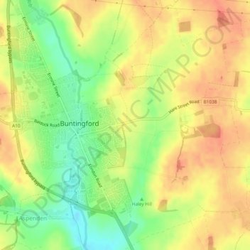
Name: Buntingford topographic map, elevation, terrain.

Location: Buntingford, East Hertfordshire, Hertfordshire, England, United Kingdom (51.93250 -0.03054 51.96049 0.01634)

Average elevation: 110 m

Minimum elevation: 81 m

Maximum elevation: 129 m

Other topographic maps

Click on a map to view its topography, its elevation and its terrain.

Gear up for your next adventure:

🧥Packable Rain Jacket - Breathable waterproof layer for unpredictable weather
🧼Biodegradable Camp Soap - Environmentally friendly cleaning for gear and body
🦯Trekking Poles - Reduced impact on joints for steep topographic climbs
🛏️Camping Sleeping Mat - Comfortable mats for sleeping outdoors
🌬️Windproof Camp Stove - Efficient cooking even on exposed mountain peaks

As an Amazon Associate, this site earns from qualifying purchases at no extra cost to you.