Geolocate

Ameglia topographic map

Click on the map to display elevation.

About this map

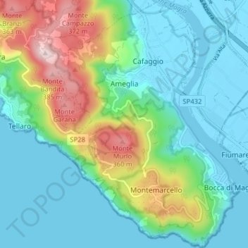
Name: Ameglia topographic map, elevation, terrain.

Location: Ameglia, La Spezia, Liguria, Italy (44.03539 9.94273 44.08131 9.99903)

Average elevation: 104 m

Minimum elevation: -3 m

Maximum elevation: 410 m

Gear up for your next adventure:

🧰Emergency Multi-Tool - Compact multi-tool for outdoor survival
👟Trail Running Shoes - Agile footwear for fast-paced topographic exploration
🎒Fully Waterproof Backpack - Total protection for photography gear and electronics
🦯Trekking Poles - Reduced impact on joints for steep topographic climbs
🍽️Titanium Camping Spork - Ultralight and indestructible eating utensil

As an Amazon Associate, this site earns from qualifying purchases at no extra cost to you.