Geolocate

Schiara topographic map

Click on the map to display elevation.

About this map

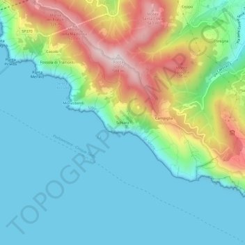
Name: Schiara topographic map, elevation, terrain.

Location: Schiara, La Spezia, Liguria, 19133, Italy (44.05344 9.76640 44.09344 9.80640)

Average elevation: 160 m

Minimum elevation: 0 m

Maximum elevation: 571 m

Gear up for your next adventure:

🧊Insulated Water Bottle - Keeps drinks cold in summer and prevents freezing in winter
🧤Thermal Hiking Gloves - Grip-enhanced gloves for cold-weather altitude trekking
🐕Hiking Dog Pack - Let your canine companion carry their own water and food
🥾Lightweight Hiking Shoes - Comfortable shoes for day hikes
🧰Survival Kit - Essential gear for emergencies in the wilderness

As an Amazon Associate, this site earns from qualifying purchases at no extra cost to you.