
Hyattsville topographic map
Click on the map to display elevation.
Hyattsville
Downtown Hyattsville underwent revitalization in the early 2000s with the development of Arts District Hyattsville, part of the Gateway Arts District, a private project which includes townhomes, live-work units, and retail space. The master developer of the 25-acre neighborhood was Bethesda-based EYA, and was constructed by EYA, PulteGroup, StreetSense, and Bozzuto Group. A Busboys and Poets restaurant opened in July 2011; other retail offerings include Yes! Organic Market, Elevation Burger, Chipotle Mexican Grill, Spice 6 Modern Indian, and Tara Thai. In the winter of 2015, a traveling exhibition platform Visual Collaborative collaborated with the Arts District Hyattsville Master Association, utilizing the Lustine Center to host a group exhibition themed Vanity.
About this map
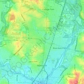
Name: Hyattsville topographic map, elevation, terrain.
Average elevation: 24 m
Minimum elevation: 1 m
Maximum elevation: 69 m
Other topographic maps
Click on a map to view its topography, its elevation and its terrain.
Sellman Estates
United States > Maryland > Prince George's County > Beltsville
Average elevation: 61 m
Mount Rainier Neighborhood Park
United States > Maryland > Prince George's County > Mount Rainier
Average elevation: 21 m
Farmington Road Estates
United States > Maryland > Prince George's County > Farmington Road Estates
Average elevation: 47 m